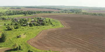


The unified federal map-scheme of agricultural lands is planned to be fully formed by the end of 2025. As a result of monitoring, up-to-date data on their areas and boundaries will be obtained.
The work on the implementation of this project is included in the state program “Earth” supervised by the Ministry of Agriculture of the Russian Federation, launched two years ago. The process of land inventory allows specialists to identify problems that prevent their involvement in the turnover, including cadastral errors.
However, to this day there remains a serious lack of information on the qualitative characteristics of the relevant territories. According to experts, agrochemical service stations subordinate to the main agrarian department of the country do not enter data into the schematic map quickly enough. They are the ones who record the state of land fertility based on the results of agrochemical, ecological, toxicological and soil surveys.
Due to the lack of data available to a wide range of people, a number of serious problems arise. For example, without detailed information about land for the agricultural sector, it is difficult for investors to determine their economic potential. As a result, they are in no hurry to invest their funds in promising projects, which slows down the development of the industry.
- Latest
- Trending


