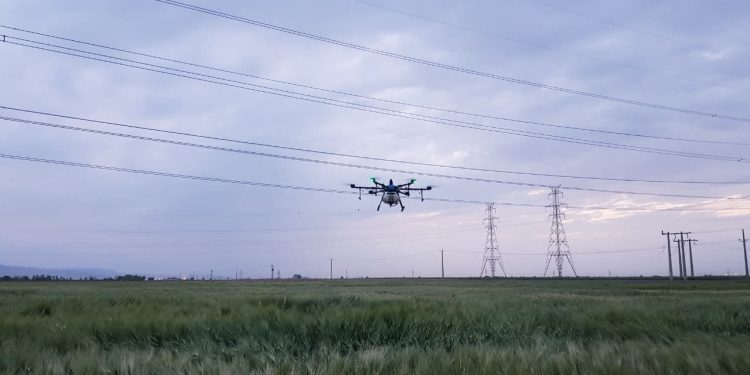
Drone technology is a phenomenal innovation that constantly affects modern society, transforming our lives and business practices.
It seems that farmers have welcomed the advent of drones with open arms, using these advanced tools to transform modern farming.
High-tech drones allow farmers and the pilots who control them to increase the efficiency of certain aspects of crop cultivation from crop control to plant planting, livestock management, crop spraying, irrigation mapping, etc.
Next, we will take a closer look at the agricultural drone market and how to use them, as well as take a look at the future of this industry and discuss the steps you need to take if you want to retrain as an agricultural drone pilot.
AGRICULTURAL DRONE MARKET ANALYSIS
Agricultural drones help to develop and optimize a system known as precision farming.
This approach to crop cultivation includes monitoring, measuring and taking measures based on real-time information about the condition of cultivated crops and livestock. In this case, instead of random decisions based on guesses, modern farmers get the opportunity to maximize yields and optimize the management structure of the farm by increasing the volume of crop production.
In recent years, the cost of agricultural drones has significantly decreased, which has led to an increase in demand and turned drones into an attractive investment object for farmers.
The agricultural drone market is expected to grow by more than 38% in the coming years. Due to population growth and climate change, the need to improve the efficiency of agriculture will only increase.
There are several options for using agricultural drones, for example:
- Exploration of land plots and crops.
- Search for weeds and spot treatment of plants.
- Control of the general condition of the crop.
- Animal husbandry management and health monitoring.
- Drones are equipped with systems and functions such as power plants, infrared cameras, GPS and navigation systems, programmable controllers and automatic flight planning. In addition, with the help of special data processing software, any collected information can be immediately used to make operational management decisions.
DRONES AND AGRICULTURE: A UNION MADE IN HEAVEN
The use of drones completely transforms the methods of cultivation of agricultural crops.
By implementing UAV technology, farmers and agricultural companies can increase yields, save time and find optimal management solutions that will ensure their success in the long term.
Nowadays, farmers face many different factors that affect their well-being, including access to water resources, climate change, winds, soil quality, weeds and insects, changing growing seasons, etc.
All this pushes farmers to take advantage of high-tech drones that can cope with such problems and ensure prompt adoption of the most effective solutions.
Agricultural drones provide farmers with access to a large amount of data that they can use to find optimal management solutions, increase yields and overall profitability.
Drones can be used to collect data on crop yields, livestock conditions, soil quality, nutrient levels, weather and precipitation forecasts, etc. Subsequently, the same data can be used to create detailed maps and make decisions based on verified information.
The agricultural industry does not neglect high-tech tools that allow optimizing business operations. The use of drones in agriculture is the next stage designed to help farmers and agricultural companies meet the changing demands of a growing market.
WAYS TO USE AGRICULTURAL DRONES: 6 INNOVATIVE METHODS
The use of drones in agriculture is becoming increasingly common.
Drones are able to help in performing time-consuming and complex tasks while reducing material costs.
It can be expected that the use of drones in agriculture will grow as the industry develops and new technologies are introduced.
Currently, there are 6 main ways to use agricultural drones:
- Soil and field analysis
At the beginning, middle and end of the harvest cycle, unmanned aerial vehicles can be used to obtain useful data on the composition and quality of the soil. With the help of 3D soil maps, you will be able to diagnose the presence of problems related to soil composition, nutrient levels or dead zones in a timely manner.
This information can help farmers determine the most effective schemes for planting and growing crops, soil care, etc. Current monitoring is able to ensure optimal use of water resources and maintain the necessary ratio of nutrients in plant care.
- Planting seeds
Planting seeds using drones has been practiced relatively recently and has not yet become widespread, however, some companies are experimenting by planting plant seeds using drones. In fact, producers are experimenting with specific systems that are programmed to scatter seeds into prepared soil.
Young companies producing unmanned aerial vehicles have played an important role in the development of unique technologies designed to solve a number of problems in the field of ecology and agriculture. For example, the company “Dronsid” (DroneSeed) uses an unmanned aerial vehicle capable of lifting a payload weighing 57 pounds / flight in the form of tree seeds, herbicides, fertilizers and water for reforestation and plant transplantation.
This technology helps to minimize the need for personal presence for planting plants in the selected area, which sometimes becomes an expensive and energy-consuming task.
This same drone technology can be adapted and applied to many types of farms, reducing landing time and labor costs.
- Crop spraying and spot spraying
To preserve rich harvests, constant fertilization and spraying is required. In the past, this was done manually by means of vehicles or aircraft. However, these methods can be called inefficient, burdensome and quite expensive.
Based on the decision of the Federal Aviation Administration (FAA), drones can be equipped with large tanks that can be filled with fertilizers, herbicides or pesticides. Using drones to spray plants is much safer and more cost-effective. Drones are able to function autonomously and can be programmed to fly on a specific schedule and route.
For example, if a fungus was found in some limited area, drones can be used to solve this problem. Given the speed of the drones, you get the opportunity to diagnose and eliminate a potential threat before it spreads throughout the farm.
Spot spraying of crops was an incredibly difficult task. If there were problems with weeds or a specific crop, it was necessary to spray the entire site.
This led to a huge waste of time and resources, since someone had to walk around the entire site. Add to this the cost of pesticides and the damage caused to the environment due to the use of chemicals.
Thanks to spot spraying with the help of drones, solving this problem requires much less time and money, including environmental protection costs.
- Crop mapping and geodetic works
One of the main advantages of using drone technology is the simplicity and efficiency of large-scale monitoring of crops and agricultural areas. In the past, satellite or airplane photos were used to get a large-scale image of the farm and detect potential problems.
However, these photos were expensive and could not guarantee the same degree of image accuracy that drones offer. Nowadays, you can not only take pictures in real time, but also chronologically arranged animation showing the growth of plants in real time.
Thanks to mapping and geodetic works with the help of drones, it is now possible to make technological decisions based on real-time data, rather than outdated photographs or practical considerations.
Thanks to sensors that take pictures in the near infrared spectrum (NIR), you can determine the health of plants based on light absorption, instantly forming a general idea of the well-being of the farm. We recently interviewed a drone pilot who used near-infrared photos to help vineyard owners diagnose the condition of their vines.
With the help of agricultural drones, you can get information such as:
The volume of the crop and the state of plant health.
Distribution of land depending on the type of culture.
The current life cycle of the culture.
Detailed maps of acreage made using GPS.
It’s simple: thanks to drones, you can use land and resources as efficiently as possible, helping farmers find optimal sites for planting crops.
- Monitoring and organization of irrigation works
Irrigation is a troublesome occupation. If your irrigation installations stretch for many miles, problems cannot be avoided. Drones equipped with thermal imaging cameras are able to diagnose irrigation problems or areas where there is too little or too much moisture.
Thanks to this information, you can create the most effective planting schemes to improve the drainage system, use natural surface runoff and avoid water accumulation that can damage sensitive crops.
Problems with water and irrigation systems not only require large monetary costs, but also can destroy your crop. With the help of drones, these problems will be detected before they can harm you.
- Real-time livestock monitoring
Some drones are equipped with thermal imaging cameras that allow the pilot to simultaneously control the drone and track livestock. This allows farmers to regularly monitor livestock with minimal time and labor costs.
The drone operator can quickly check the herd to make sure there are no injured or missing animals, as well as the appearance of young animals. Drones are used for constant monitoring of the herd, which was once an expensive and time-consuming occupation.
In addition, photos taken with a thermal imager help to track predators, being a great help for the owners of some farms.
Start your career as an agricultural drone pilot
Maximizing yields, minimizing costs and creating a new generation of farms.
It’s easy to see why agricultural drones are so popular. Farms and agricultural enterprises that use drones in their activities will quickly displace those who refuse this opportunity from the market.
And this means that agricultural drone pilots will become a key asset for these companies.
It sounds like an invitation to learn an exciting and promising profession.
The agricultural drone market is still in its infancy. And the biggest factor hindering its growth is the lack of experienced pilots.
Fortunately, if you are reading these words, you are only one click away from becoming a certified drone pilot. Thanks to high-quality training and a sincere interest in this field of knowledge, you can influence the ways of cultivating crops and secure a job in a profitable and promising industry.
As a professional pilot of an agricultural drone, you will always be up to date with the latest data on the farm, livestock and soil condition, using this information to quickly assess agricultural production.
After receiving the certificate, you can choose one of the possible ways to achieve success in working with agricultural drones, for example:
Work as a consultant offering an assessment of soil conditions and the creation of maps to optimize the structure of the farm, based on photographs taken with a thermal imager and processed using modern software.
Creation of automated systems of unmanned aerial vehicles for operating farms, providing planting, spraying and regular management of agricultural crops.
Contract work, including regular crop monitoring, spraying and detailed analysis to maximize yield.
Work on farms of large agricultural companies that need an experienced pilot of agricultural drones.
Creation of detailed maps of lawns and other land-use objects located outdoors.
Conducting in-depth research on the survival and viability of wild plants and crops in various weather and climatic conditions.
Be sure that in the future, the number of jobs, types of contracts and work using drones, as well as promising business development opportunities will continue to increase as drones gain popularity.


