Arable farmers can use AgroVision’s mineral planner to check their manure utilization space. ‘That prevents them from being surprised afterwards by exceeding the usage standards,’ says cultivation specialist Kees Vogelaar of AgroVision.
The current high fertilizer prices also make it attractive for arable farmers to use such modules. ‘They want to use organic fertilizer as optimally as possible to limit the costs of fertilizer’, says Vogelaar. The mineral planner is an additional module to the cultivation registration system of AgroVision, a company that provides software solutions.

The planner cannot do without crop registration. It ensures that manure consumption, soil studies and cultivation plans are automatically included in the calculation. The mineral planner calculates the available space and provides growers with insight into the utilization of the available space for all types of manure.
Exact composition
The cultivation specialist of AgroVision knows that many arable farmers make a mineral plan in winter with their advisor. ‘But the actual consumption often deviates from the plan. Then there is still no knowledge of the exact composition of organic manure’, he says. When applying manure, the arable farmer receives the manure analysis and can see what nitrogen and phosphate has been used. ‘With the actual figures you can adjust the calculation and you have an idea of what the remaining space is,’ explains Vogelaar.
Database
The maximum usage standard is recorded in the program’s database. The arable farmers have to set their own data, such as the crop and the soil type. The correct standard is automatically linked to this. With the mineral planner they have insight into how close they come to the maximum. ‘Red numbers appear when a value is exceeded’, says the cultivation specialist from AgroVision.
Incidentally, the starting point for classification of phosphate classes has recently been changed from Pw to determination based on P-CaCl2 and P-Al. The transition phase of soil samples is four years. This year, arable farmers are therefore allowed to use samples taken after 15 May 2018.
Maarten Janse from Wolphaartsdijk is experimenting with precision farming. Images from a satellite, helicopter or drone show how the potatoes grow and where extra seed potatoes or fertilizer is needed. The Zeeland arable farmer has been applying precision farming to one of his plots for several years now. “I can see that it works and I have a good feeling about it,” he says. “It can’t hurt, though I’ll keep using my common sense.”
Maarten Janse (36) graduated from the Higher Agricultural School in Dronten in 2004. He has a partnership with brother Hubrecht (45) Janse. Hubrecht manages the saline crops and farm shop and Maarten the regular 60-hectare arable farm and landscape campsite. It has now grown from fifteen to 75 places. At the time of this conversation, Janse was busy pruning, mowing the lawn and renovating the toilet block.
Heterogeneous soil composition
Potatoes and sugar beet make up the bulk of the crop on the arable farm. He also grows wheat, grass seed and sweet corn. The heterogeneous soil composition is characteristic of the arable farm located a few kilometers outside Wolphaartsdijk. The land is located directly on the Veerse Meer and was only reclaimed around 1968.
I can see that precision farming works, although I continue to use my common sense MAARTEN JANSE, ARABLE FARMER
Janse herself speaks of one of the youngest parts of the Netherlands. The area previously consisted of mud flats and salt marshes. The bottom here consists of young marine clay. ‘The soil quality on a plot varies greatly, which makes precision farming interesting,’ says Janse. Here too he grows potatoes and applies variable fertilization with both organic and inorganic manure.
High-tech sensing project
Three years ago, Janse became acquainted with a high-tech sensing project through his membership of the Zeeuws Agrarisch Youth Contact (ZAJK). Within this project, images are made of the potatoes. ‘These images and information from site-specific soil research, leaf stalk research, yield determination and a soil scan provide a nice overall picture,’ he says.
In 2016 he started controlling his own tools and those of the contracting company, with the information obtained. The images are made by a satellite, drone or helicopter. If possible, he works with satellite images and otherwise with images from a helicopter. The satellite images come in once a week. ‘If there are too many clouds, I will provide images from the air,’ says Janse.
Insight into different factors
The images provide insight into factors such as growth pattern, leaf mass and soil structure. Janse shows some maps from 2017. ‘It is heavier ground. The spring remained dry for a long time, but once enough moisture had fallen, there was an explosive growth. I can see where the ground is firmer, or the spots I’ve turned over myself with the tractor.’
The soil is lighter on part of the plot. The images make that clear. Janse uses less seed there than on the heavy soil. ‘We saw 4 percent more stems, but also 20 percent more yield per hectare. Ultimately, the yield of potatoes there was 16 tons higher. We often have more yield on heavier soils. This year we will perform a baseline measurement. Previously, we mainly relied on our experience.’
job card
A task card is drawn up on the basis of the images obtained, which is entered on the planters of contracting company Gebroeders Van den Dries from ‘s-Heerenhoek. This company is on a par with Janse and, according to him, is open to new technological developments. With the task card on the machine it can be determined on a site-specific basis how much seed potatoes and crop protection products are needed, but also which type and how much fertilizer is needed. The images also show where and whether the potato plants are dying.
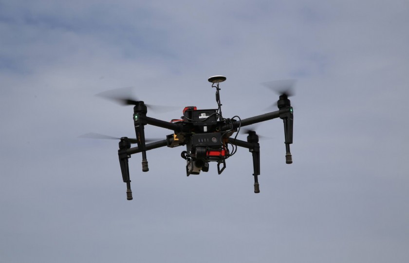
Own drone
For the time being, Janse is limiting this form of precision farming to potato cultivation. For wheat, the task cards are only used for nitrogen fertilization. When sowing, the amount of seed is less precise than with the potatoes.
Janse: ‘The highest yield can be obtained from potato cultivation. Working with task cards is technically possible for sugar beets, but this mainly concerns crop protection and herbicides. I haven’t applied that yet.’ The arable farmer from Zeeland expects precision agriculture and robotization to advance further. He also has a drone that can take images. It’s more out of a hobby, but he puts the images he makes with it on social media. You can find it on YouTube, for example, by searching for ‘Maarten Janse potatoes’.

