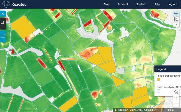
Rezatec – a UK based company focused on the analysis and interpretation of satellite data – has in collaboration with AHDB Potatoes investigated the effectiveness of using satellite data to map the extent of potato crops in pilot locations across England and Scotland.
Looking at four sites spread across the UK, Rezatec applied its proven crop identification techniques to map locations of potato crops, down to individual fields, some of which just a few hundred square meters in size.
A crop health map was then generated to highlight the extent and abundance of each potato field. This enables AHDB to better understand production areas of potatoes in the UK from season to season at a micro level.
Rezatec applies its geospatial data techniques to extract specific spectral indices across the growth cycle to create a signature that identifies the crop, using both optical and radar satellite data sources. By applying its in-house machine learning algorithms to these indices, Rezatec can distinguish potato from other crop types with up to 95% accuracy.
Additionally, through active remote sensing monitoring, Rezatec can also assess variables of crop performance, e.g. health, against the crop model through the growing season, and, using its data science techniques provide growers with critical information to take corrective action and ultimately increase crop yields.
Dr Jim Dimmock, Resource Management Scientist at AHDB:
“It is evident from our collaboration with Rezatec that the application of satellite data for mapping crop extent is of great value and compared to more traditional methods, we were impressed by the ability to scale across large areas with high levels of accuracy.”
Dr Andrew Carrel, Chief Technology Officer at Rezatec:
“Rezatec’s agriculture management services are very versatile, ranging from identifying crops at a field, and even sub-field level, and monitoring crop performance, up to macro-level analytics to support commodity crop trading for multiple end-users including Government and traders.”
Rezatec provides its agricultural management services around the world to a wide range of agricultural end-users from sugar cane and wheat farmers in Mexico to dairy farmers in the UK.